Route and Location of Sail Amsterdam 2025
Everything you must know

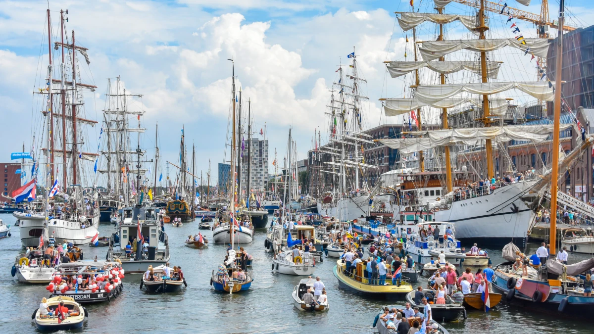
Sail Amsterdam 2025 is set to flood the city with excitement as hundreds of tall ships, navy vessels, and historic boats sail right into the heart of Amsterdam.
From August 20 to 24, the waterfront will turn into a lively, open-air festival with ship tours, music, and nonstop festivities.
But with so much happening across a massive area, it’s easy to miss the highlights or end up in the wrong spot.
This article breaks down the full route and event layout of Sail Amsterdam 2025, so you know exactly where to be and when.
The sail-in parade: where it begins and how it flows
The event officially begins with the Sail-In Parade on 20 August (Wednesday), when hundreds of tall ships, navy vessels, and heritage boats travel together into Amsterdam.
- Starting point: IJmuiden Sea Locks on the North Sea coast
- Route: Ships sail 22 km (13.5 miles) through the North Sea Canal
- Arrival: First ships reach Amsterdam around 2 pm, continuing into the evening
- Duration: About 3 hours
The North Sea Canal will be closed to other vessels during the parade. Spectators can view the ships from multiple towns and bridges along the canal.
Book Cruise for ParadePro tip: For a calmer experience and great photos, watch from canal towns like Zaanstad, Velsen-Zuid, or Halfweg, before the ships even reach the city.
How the ships enter Amsterdam: final stretch of the route

After passing the Oranjesluizen (Orange Locks), the ships enter the IJ River and sail westward through Amsterdam.
This final leg takes them past key riverfront neighborhoods before reaching their designated mooring points on both sides of the IJ, the city center (south bank) and Amsterdam-Noord (north bank).
The full mooring stretch runs from Java-eiland in the east to Houthavens in the west.
Main mooring zones: where the ships will be docked
Once docked, the tall ships line up along the IJ river. Some ships will be open to the public, while others serve as official or private vessels.
Here’s a breakdown of where they’ll likely moor:
| Zone | Side | Nearby Areas | What You’ll Find |
| Java-eiland to PTA | City Center (South) | Java Island, Piet Heinkade, Cruise Terminal | Most tall ships, navy ships, historic vessels |
| NDSM to Houthavens | Amsterdam-Noord (North) | NDSM Wharf, Buiksloterweg, Disteldorp | Some ships, support vessels, quieter spots |
| IJhaven Quay | South | Near Muziekgebouw and Passenger Terminal | Central viewing area, major access point |
👉 To help plan your visit, our tips for the Sail Amsterdam 2025 guide offers practical advice on navigating mooring zones and avoiding crowds.
Wayfinding tip: If you’re unsure where to start, use the Passenger Terminal Amsterdam (PTA) as your anchor point. It’s near Central Station and has wide walkways and clear views of docked ships.
Best locations to watch the Sail-In and Sail-Out parades

Avoiding crowded or poorly located spots can make a huge difference in your experience.
Here are the top locations for viewing both the entry and exit of the fleet:
Best viewing spots for the Sail-In Parade:
- IJmuiden Locks – See the ships emerge from the sea
- Zijkanaal B (Halfweg) – Great canal-side stretch, less crowded
- Java-eiland – Early mooring area with wide views
- Piet Heinkade – Central and busy, but popular for a reason
For the Sail-Out Parade on August 24:
- Java-eiland – Ships begin their departure here
- Oranjesluizen (Orange Locks) – See them exit the canal
- Canal bridges along the North Sea Canal – Good for a long goodbye
Timing tip: Arrive at least 90 minutes before the scheduled parade times. The best spots fill up quickly, and crowd movement slows as the ships approach.
👉 Make your Sail Out Parade even more memorable by being a part of it. Just book your cruise and sail with the tall ships as they bid farewell to Amsterdam.
Understanding the full stretch: from sea to city
To help visualize the event better, here’s a simplified overview of the full route the ships take from sea to harbor:
| Segment | Details |
| IJmuiden Sea Locks | Ships enter from the North Sea |
| North Sea Canal (22 km) | Ships sail inland; road bridges may open for passage |
| Oranjesluizen (Locks) | Entry point to the IJ River |
| IJ River Stretch | Ships sail westward through central Amsterdam to reach final docking zones |
| Final mooring areas | Spread along both the south (Piet Heinkade) and north (NDSM) sides of the river |
Tip: The IJ River route is long, but bike rentals, free ferries, and trams make moving between mooring zones fairly easy. Avoid driving! Parking will be difficult during the event.
Landmarks that help you get around easily
The festival covers a large part of the city’s waterfront, but a few landmarks can help you stay oriented, especially when moving between areas.
| Landmark | Location | Usefulness |
| PTA Cruise Terminal | Piet Heinkade (South) | Main starting point; accessible and centrally located |
| Muziekgebouw aan ‘t IJ | Next to PTA | Great visual anchor; often a quiet sitting spot |
| Amsterdam Central Station | South of IJ River | Transport hub, ferry access to North Amsterdam |
| NDSM Wharf | Amsterdam-Noord | Quieter docks and a creative backdrop for ship watching |
Navigation tip: Free ferries run regularly between Amsterdam Central Station and Buiksloterweg, as well as Central Station and NDSM Wharf, which is a quick and easy way to cross the IJ River without spending a cent.
👉 For a full schedule of activities and performances throughout the festival, check out the Sail Amsterdam 2025 schedule and events guide.
Frequently Asked Questions
Here are some questions tourists ask about the Route and Location of Sail Amsterdam 2025.
Where exactly is the best place to start my visit if I only have half a day?
Start at the Passenger Terminal Amsterdam (PTA) if you’re short on time. It’s near Central Station, easy to reach by public transport, and centrally located within walking distance of many moored ships and riverbank attractions.
Can I follow the ships by boat during the Sail-In Parade?
No. Private or non-participating boats are not allowed on the North Sea Canal during the Sail-In and Sail-Out parades. These waterways are temporarily closed to all other traffic to ensure safety and smooth passage of the ships.
Are there bridges that might open during the Sail-In route, affecting road traffic?
Yes. Several road and railway bridges along the North Sea Canal will open for the fleet to pass through. If you’re driving near towns like Zaandam or Halfweg, expect temporary traffic delays during the Sail-In on August 20 and Sail-Out on August 24.
Can I access both sides of the IJ River easily as a pedestrian?
Absolutely. Free public ferries connect both sides of the IJ River, with the Central Station to Buiksloterweg and Central Station to NDSM Wharf ferries being the most popular. They run every few minutes, even during the event.
Are there areas along the route with limited access or restricted zones?
Yes. Some naval ships or private tall ships may dock in restricted access zones, especially near the NAVAL docklands or Oranjesluizen. These areas may be closed off or require special credentials for entry.
Can I bike the entire length of the Sail event area?
Yes, and it’s one of the best ways to get around. Amsterdam’s cycle paths run along the IJ River, particularly on the south bank. However, during peak times, certain pedestrian zones may restrict bikes, so park nearby and walk when needed.
Which ferry should I take if I want to explore the NDSM side of the festival?
Take the free ferry from Central Station to NDSM Wharf. It’s a scenic 15-minute ride that brings you straight to one of the event’s mooring zones, perfect if you’re looking for a quieter, less crowded area to explore.
Will there be signage to help navigate the mooring zones and route?
Yes. The city installs clear signage and color-coded flags along the waterfront and near ferry points. Printed maps and a digital event guide or app are also expected closer to the date.
Image Courtesy: Canalsofamsterdam.com